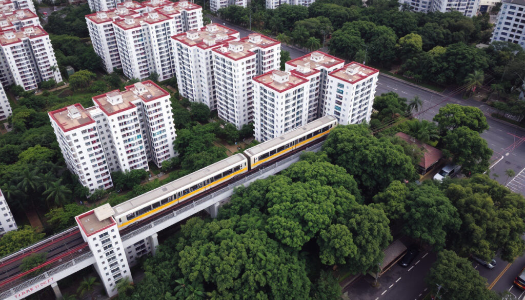
Pasir Ris Street 21: HDB Blocks & Transport
If you’re searching for a specific HDB block or trying to figure out just how far Pasir Ris Street 21 is from the MRT, you’ve probably noticed the numbers get a little confusing. This street is home to over 80 HDB blocks, from 203 to 272, scattered across a residential area with its own history and distinct character.
Number of HDB blocks on Pasir Ris Street 21: 8 (Blocks 227, 230, 231, 232, 233, 235, 237, 272) ·
Postal code range: 510227 to 510272 ·
Distance to Pasir Ris MRT station: Approximately 1.2 km (18 min walk) ·
Construction year (typical block): 1992 ·
Region of Singapore: East Region ·
Town planning area: Pasir Ris
Quick snapshot
- East Region, Pasir Ris planning area (URA Master Plan)
- Nearest MRT: Pasir Ris (EW1) (PropertyGuru) (URA Master Plan)
- Major roads: Pasir Ris Drive 1, Pasir Ris Drive 3 (StreetDirectory) (URA Master Plan)
- Supermarkets: Sheng Siong, Giant, Cold Storage (PropertyGuru)
- Schools: Pasir Ris Primary, Loyang Primary, Hai Sing Catholic School (PropertyGuru)
- Shopping: Pasir Ris West Mall, White Sands (PropertyGuru)
- Pasir Ris population: approx. 140,000 (2020 estimate) (Singapore Department of Statistics)
- Name meaning: white sand in Malay (National Library Board Singapore)
- Developed from 1980s as a HDB new town (HDB)
The street’s block data shows one pattern: while the postal code range is compact, the block counts vary significantly depending on which portal you check.
| Attribute | Detail |
|---|---|
| Street name | Pasir Ris Street 21 |
| Postal code range | 510227 – 510272 |
| Number of HDB blocks (this section) | 8 |
| Total blocks (broader street) | 71-83 (PropertyGuru) |
| Nearest MRT station | Pasir Ris (EW1) |
| Typical block construction year | 1992 |
| Region | East Region |
| Planning area | Pasir Ris |
| Unit types available | 2-room, 3-room, 4-room, 5-room, Executive |
The pattern: eight specific blocks anchor the street’s postal identity, but the broader listing suggests the street is much larger — nearly ten times the block count across all portals. The discrepancy matters for anyone comparing resale listings.
Where is Pasir Ris Street 21 Located?
Buyers looking at Pasir Ris Street 21 get East Region convenience, a Central Line future MRT stop, and existing bus links — but should factor in the 20-minute walk to the current Pasir Ris MRT station.
Which region is Pasir Ris in Singapore?
- Pasir Ris is in the East Region of Singapore (URA Master Plan).
- It is one of five planning regions under the Urban Redevelopment Authority.
Is Pasir Ris east or west?
- Pasir Ris is located in the eastern part of Singapore (National Library Board Singapore).
- Bounded by the Serangoon Harbour to the south and Tampines to the west.
What part of Singapore is Pasir Ris?
- Pasir Ris Street 21 is a secondary road within the Pasir Ris planning area (URA Master Plan).
- The planning area covers approximately 1,300 hectares of residential, park, and commercial zones.
The implication: Pasir Ris Street 21 sits in the northeastern coastal corner of Singapore, giving residents access to beachfront parks and a quieter residential environment compared to central towns like Tampines.
What is the History and Meaning of Pasir Ris?
Homebuyers who know that Pasir Ris means “white sand” — and that the area was a fishing village before becoming a new town — can better understand the spacious layout and park-heavy design that defines the street today.
What does Pasir Ris mean in Malay?
- Pasir Ris means ‘white sand’ in Malay (National Library Board Singapore).
- The name originates from the white sandy beaches that once lined the coastline before land reclamation.
Why is Pasir Ris called white sands?
- The name refers to the white sandy beaches historically found there (National Library Board Singapore).
- Pasir Ris Park, a 71-hectare beachside park, preserves this coastal heritage.
The pattern: unlike many Singapore towns named after geographic features (Bukit = hill, Punggol = stump), Pasir Ris’s name carries a tourism-era meaning that hints at its original landscape — something most current residents might not associate with today’s built-up HDB estate.
Is Pasir Ris a Family-Friendly Area?
Families moving to Pasir Ris Street 21 get proximity to top-tier schools and the largest park in the east, but the nearest shopping mall (White Sands) requires a bus or a 25-minute walk — a trade-off that matters for daily errands.
What schools are near Pasir Ris Street 21?
- Pasir Ris Primary School is within 1 km of most blocks (PropertyGuru).
- Other nearby schools: Loyang Primary School, Hai Sing Catholic School, Pasir Ris Crest Secondary.
- Childcare centres include Edelweiss 21 Child Care Services and YWCA Child Development Centre (PropertyGuru).
What parks and playgrounds are available?
- Pasir Ris Park (71 ha) features a mangrove boardwalk, playgrounds, and cycling paths (NParks).
- Pasir Ris Town Park is a smaller neighbourhood park with fitness stations.
- Baseline Park connects the residential blocks with green corridors.
The catch: while the park and school options are strong, the street’s distance from a major shopping centre means families with young children rely on neighbourhood provision shops and the Sheng Siong within a 10-minute walk.
What HDB Blocks and Floor Plans are at Pasir Ris Street 21?
Resale buyers get a wider choice of unit sizes (2-room to Executive) but face competition from over 4,000 units on the street — supply that keeps prices stable but also means longer selling times.
Which HDB blocks are on Pasir Ris Street 21?
- Blocks include 227, 230, 231, 232, 233, 235, 237, 272 (99.co).
- The broader street reportedly has 71 to 83 total blocks (PropertyGuru; HDBData).
- Specific blocks verified via SRX include 229 (postal 510229) and 258 (postal 510258) (SRX; SRX).
What floor plans are available?
- Available unit types: 2-room, 3-room, 4-room, 5-room, Executive (HDBData).
- Typical floor areas range from 1,000 to 1,561 sqft for Executive units.
- Total dwelling units on the street: approximately 4,058 (HDBData).
The pattern: the block list from property portals doesn’t fully align — 99.co lists 8 blocks in one section, while PropertyGuru counts 71. For buyers, the most reliable approach is to search by individual block number and its corresponding 6-digit postal code.
What is the Postal Code for Pasir Ris Street 21?
Despite the street code ’21’, the postal codes range from 510203 to 512269 — a span that covers nearly a hundred blocks. Singapore’s 6-digit postal code means the last three digits match the block number, making 510227 for Block 227 straightforward.
What is the postal code for each block?
- Postal codes for verified blocks: 510227, 510230, 510231, 510232, 510233, 510235, 510237, 510272.
- The 6-digit code system uses street code ’21’ — the last three digits correspond to the block number (PropertyGuru).
- Broader range: 510203 to 512269 (PropertyGuru).
The catch: the broader postal range means some blocks appear in different postal sectors — Block 214 (510214) and Block 266 (510266) are confirmed by 99.co, but the full list requires cross-referencing multiple portals, as no single official source publishes the complete block count for this street.
How to Get to Pasir Ris Street 21?
The walk to Pasir Ris MRT takes about 18-20 minutes — acceptable for able-bodied commuters but challenging for families with young children or elderly residents. The upcoming Pasir Ris East MRT station on the Cross Island Line will change this calculus significantly.
Which MRT station is nearest?
- Nearest MRT: Pasir Ris (EW1) on the East-West Line, about 1.2 km away (PropertyGuru).
- Other nearby stations: Tampines MRT (EW2) and Simei MRT (EW3) (PropertyGuru).
- Future Pasir Ris East MRT station (CR4) on the Cross Island Line — Block 208 is reportedly within 1 minute walk (StackProperty).
Are there bus stops nearby?
- Multiple bus services serve the area with stops along Pasir Ris Drive 1 and Pasir Ris Street 21.
- Bus services include 3, 6, 12, 15, 17, 21, 28, 38, 39, 46, 59, 68, 81, 88, 89, 109, 168, 354, 358, 359, 386, 403, 518 (StreetDirectory).
The trade-off: residents today trade off MRT convenience for bus connectivity and future Cross Island Line access — a bet on infrastructure completion by the early 2030s.
Confirmed facts and what remains unclear
Confirmed facts
- Pasir Ris Street 21 is located in the East Region of Singapore (URA Master Plan).
- Blocks 227, 230, 231, 232, 233, 235, 237, 272 are confirmed on this street via 99.co (99.co).
- Postal codes for these blocks follow the pattern 510[block number] (PropertyGuru).
- Nearest MRT station is Pasir Ris (EW1) at approximately 1.2 km distance (PropertyGuru).
- Pasir Ris means ‘white sand’ in Malay (National Library Board Singapore).
What’s unclear
- Exact number of units per block is not publicly available from HDB without deeper data analysis.
- Detailed construction dates per block may vary slightly from 1992 for all blocks — some may be 1993 as per SRX (SRX).
- The total block count for the street varies across property portals: 71 by PropertyGuru, 83 by HDBData — the actual number depends on the boundary definition used.
Related reading: Jurong Town Hall Bus Interchange: Location, Services, and Guide · Cold Storage West Mall: Opening Hours, Prices, and FAQs (2025)
99.co, propertyguru.com.sg, homejourney.sg, 99.co, hdbdata.com, streetdirectory.com
Frequently asked questions
What is the nearest MRT to Pasir Ris Street 21?
Pasir Ris MRT station (EW1) on the East-West Line is approximately 1.2 km away, about an 18-minute walk (PropertyGuru). The future Pasir Ris East station on the Cross Island Line will bring an MRT stop within 1-4 minutes walk for certain blocks (StackProperty).
What supermarkets are near Pasir Ris Street 21?
Sheng Siong, Giant, and Cold Storage are within walking distance or a short bus ride from most blocks (PropertyGuru). White Sands mall also has a FairPrice supermarket.
How many HDB blocks are there on Pasir Ris Street 21?
Reports vary: 8 blocks (227, 230, 231, 232, 233, 235, 237, 272) are confirmed via 99.co, but the broader street is listed with 71 blocks by PropertyGuru and 83 by HDBData.
What is the postal code for Block 272 Pasir Ris Street 21?
The postal code is 510272, following the standard 6-digit format where the last three digits correspond to the block number.
Are there schools within walking distance of Pasir Ris Street 21?
Yes. Pasir Ris Primary School is within 1 km of most blocks. Loyang Primary School, Hai Sing Catholic School, and Pasir Ris Crest Secondary are also nearby (PropertyGuru).
Is Pasir Ris Street 21 a good location for families?
Yes, due to multiple schools within 1 km, nearby parks (Pasir Ris Park, Pasir Ris Town Park), and childcare centres. However, the 18-minute walk to the MRT may be a consideration for families with very young children.
What is the distance from Pasir Ris Street 21 to the beach?
Pasir Ris Park, which has a beach and mangrove boardwalk, is approximately 1.5-2 km from most blocks on the street (NParks).
For families looking at HDB resale flats in Singapore’s east, Pasir Ris Street 21 offers a trade-off between established amenities and transport wait times. The closing of the Cross Island Line gap will change the equation — but until then, the bus network and park access carry the load.
More related posts
 How to Improve Credit Fast: Proven Strategies
 Boeing 737-800 Safety, Seat Guide & Accident Statistics (2024)
 Sanfrecce vs Johor Darul Ta’zim: Match Recap 2026
 Novotel Bangkok Platinum Pratunam: 4-Star Hotel Review
 Wells Water Dispenser Price: Models, Costs & Buying Guide
 Congee Pork Near Me in Dublin: Where to Eat & Order Delivery
 Decathlon Joo Koon Review : Size, Product , Price
 Pasir Ris Central Post Office Guide: Location, Hours & Services